When we say geospatial data or geospatial mapping, we simply mean that the features and maps illustrate locations in an earth-based reference system. When we start working with thematic data layers and overlaying them to see where different types of features overlap, storing the data in an earth-based coordinate system ensures that locations at identical coordinates in different data layers are represented at the same location.
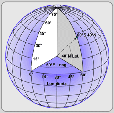
An earth-based reference system provides a mechanism by which to map geographic coordinates anywhere on earth. You’re already familiar with one of them: latitude and longitude. These are actually angular measurements in degrees relative to the center of the earth. However, they can also be represented on the surface of the globe as a network of parallel horizontal circles (“parallels”) that increase in length from the poles, and vertical circles (“meridians”) that are equal in length and intersect at the poles.
A projection must be employed to represent the 3-dimensional surface of the earth on a 2-dimensional plane like a paper map or a digital map on a flat screen. One of the earliest projections, the equirectangular projection, maps meridians to vertical straight lines of equal spacing and parallels of horizontal straight lines of equal spacing, similarly to a 2-dimensional cartesian coordinate system. Geographic coordinates are often referred to in geospatial mapping literature and software as X (longitude) and Y (latitude) coordinates.


The equirectangular projection distorts the shape, size, angles, and distances between features on the surface of the earth. More sophisticated map projections employ various techniques to preserve one or more of these characteristics, but all introduce some level of distortion. However, as the video below explains these distortions decrease with increasing scale — that is, as you zoom in closer and closer to the earth’s surface, these distortions becomes less pronounced. The point is to be aware that all geospatial data and maps use some sort of projection, that map projections are necessary but imperfect representations of the earth, and there are many different map projections that can be used depending on the location, extent, and purpose of the map.